
Tropical Storm Edouard threatens Louisiana, Texas coasts. Maps show the forecast path.
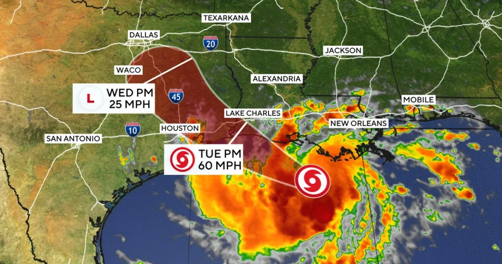
Tropical Storm Edouard Threatens Louisiana Coast
Bizeconanalysis.com – Tropical Storm Edouard threatens Louisiana and eastern Texas as the slow-moving system crawls westward across the Gulf of Mexico. Carrying maximum sustained winds of 40 mph, the storm sat roughly 140 miles southeast of Cameron, Louisiana, and 175 miles southeast of Port Arthur, Texas, on Monday evening. National Hurricane Center forecasters in Miami placed landfall along the northwestern Gulf Coast by Tuesday, bringing sustained winds, heavy rainfall, and a potential surge of several feet above normal tide levels.
A Marginal Storm With Major Hazards
At 40 mph, the system clears the tropical-storm threshold by just one mile per hour. That razor-thin margin, however, does not soften the danger. Slow-moving systems of this type can linger over a fixed area for hours, repeatedly dumping rain bands onto the same neighborhoods and roadways. Forecasters noted the storm was expected to strengthen modestly over the following day, broadening its wind field even if core intensity stays in the lower tropical-storm range.
The sluggish westward pace amplifies the flooding threat. Unlike a fast system that sweeps through in a few hours, a stalled storm can park its heaviest bands over a single county for an extended period, overwhelming drainage infrastructure and turning normally dry creek beds into rushing channels.
Rainfall and Surge Outlook
The NHC outlined a tiered rainfall forecast: 3 to 6 inches across parts of coastal Texas, with isolated pockets potentially reaching 9 inches. Southwestern Louisiana is projected to receive 2 to 3 inches. For communities built on flat, poorly drained terrain, those figures translate into concrete flash-flood risk.
“Could produce flash flooding, especially in low-lying and urban areas.”
Beyond rain, forecasters flagged the possibility of up to 3 feet of storm surge in coastal zones. Where many homes and critical infrastructure sit within a few feet of mean sea level, even a modest surge can inundate ground-floor structures, contaminate wells, and render coastal roads impassable. Surge and heavy rain arriving simultaneously compound the hazard: wind-driven water pushed inland meets water falling from the sky, merging into a single rising floodplain.
What the Warning Means for Residents
A tropical storm warning is in effect from Port Bolivar, Texas, to the Vermilion/Cameron Parish Line in Louisiana. Under the NHC advisory framework, that designation signals tropical-storm-force conditions — sustained winds of at least 39 mph with associated rain and flooding — expected within 24 hours in the warned area. It triggers standard local-government actions: opening shelters, pre-positioning sandbags, issuing boil-water advisories, and closing schools or workplaces if conditions warrant.
For residents in the warned corridor, practical steps include securing loose outdoor items, ensuring vehicles are fueled and parked away from flood-prone streets, reviewing evacuation routes in case surge or flooding closes primary roads, and keeping a go-bag ready with medications, documents, and a charged phone. The slow speed of the storm means the preparation window may stretch over several hours rather than compress into a frantic final hour.
Seasonal Context
Edouard marks the fifth tropical storm of the 2026 Atlantic hurricane season. The naming sequence, which alternates between two lists of 21 names each year, places the system in the second half of the current alphabetical cycle.
Frequently Asked Questions
When is the storm expected to make landfall? NHC forecasters placed landfall along the northwestern Gulf Coast by Tuesday, with the system tracking slowly westward across the Gulf of Mexico.
How much rain should residents expect? Coastal Texas faces 3 to 6 inches with isolated spots up to 9 inches; southwestern Louisiana is projected at 2 to 3 inches.
What does a tropical storm warning mean for my area? It signals that sustained winds of at least 39 mph, with associated rain and flooding, are expected within 24 hours. Local governments typically open shelters, pre-position sandbags, and may issue boil-water advisories.
How high could storm surge reach? Up to 3 feet in coastal zones, which can inundate ground-floor structures and contaminate wells in areas near sea level.