
Potential first Atlantic tropical cyclone of year developing off Texas Gulf coast
Potential First Atlantic Tropical Cyclone of 2026 Develops Off Texas Gulf Coast
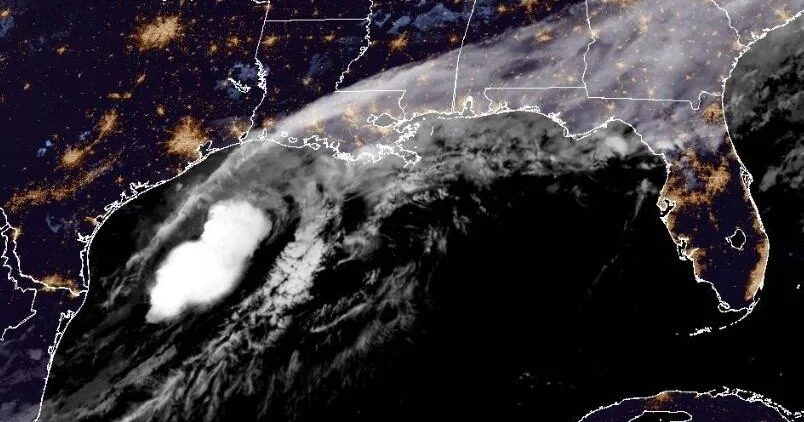
Potential first Atlantic tropical cyclone of year – Meteorologists are closely tracking the possible first tropical cyclone of the 2026 Atlantic hurricane season, which is currently forming near the Texas Gulf Coast. The system, identified as a tropical disturbance, has the potential to evolve into a fully developed storm by Wednesday, threatening to deliver “life-threatening flash flooding” across parts of the region. This development comes amid ongoing heavy rainfall that has already submerged areas in the southern United States, prompting communities to prepare for additional downpours throughout the week.
Initial Advisory Issued as System Intensifies
The National Hurricane Center (NHC) released a preliminary advisory on Tuesday, marking the first step in monitoring the emerging system. Although it is still classified as a tropical disturbance, the NHC has given it the designation of “Potential Tropical Cyclone One,” signaling that it could soon meet the criteria for a tropical storm. According to the latest update, the system is situated approximately 15 miles east-southeast of Corpus Christi, Texas, as of early Wednesday local time.
The disturbance is moving northeast at a slow pace of 5 miles per hour, with maximum sustained winds currently at 30 mph. While this is below the 39 mph threshold required for classification as a tropical storm, the NHC has noted that the system is expected to gradually strengthen. The advisory highlights that the storm could transition into a tropical storm by the end of the day, though it may weaken as it moves farther inland.
Forecasted Path and Impact on Coastal Regions
The NHC has outlined the projected trajectory of the system, stating that it will likely travel along or close to the upper Texas coast during the day. As it progresses, the storm is anticipated to shift inland, potentially affecting extreme eastern Texas and southwestern Louisiana by nightfall. This movement could lead to significant weather changes, with the system expected to generate substantial rainfall and localized flooding.
A key concern is the potential for dangerous flooding conditions. The NHC warned that the system could produce rainfall totals ranging from 5 to 10 inches, with some areas near the Gulf Coast possibly receiving up to 20 inches of rain by Thursday. Such volumes are sufficient to trigger “dangerous to life-threatening flash flooding,” particularly in low-lying regions and near waterways. The forecast also indicates that the storm’s influence will extend east-northeast, impacting southern and central portions of Louisiana, Mississippi, and Alabama, as well as western parts of Georgia and the Florida Panhandle.
“The system should move along or roughly parallel to the upper Texas coast today,” said the National Hurricane Center. “It is expected to move farther inland over extreme eastern Texas or southwestern Louisiana tonight.”
Residents along the Gulf Coast are being urged to take precautions, as the storm’s progression could lead to hazardous conditions. In Louisiana, a tropical storm warning has been issued for the coastal area from Sabine Pass to Morgan City, indicating that tropical storm conditions are likely within the next 24 hours. Meanwhile, a tropical storm watch has been posted from Sabine Pass to Sargent, Texas, as the storm approaches that region.
Projected Effects on Major Cities
Several major urban centers are at risk of experiencing prolonged periods of heavy rain. Cities such as Dallas, Houston, San Antonio, and New Orleans are forecast to see excessive rainfall, which could strain drainage systems and lead to widespread flooding. The NHC has emphasized that these areas should remain vigilant, as the storm’s remnants may linger for days, contributing to further weather disruptions.
While the primary threat lies in the coastal regions, the inland areas are also in for a challenging week. The combination of record rainfall and the approaching tropical cyclone has raised concerns about the cumulative effect on infrastructure and daily life. Emergency management teams are working to coordinate response efforts, ensuring that resources are allocated effectively to mitigate the impact of the storm.
“The disturbance is forecast to gradually strengthen and could become a tropical storm today,” the NHC continued. “It is expected to produce rainfall totals of 5 to 10 inches, with isolated higher totals near 20 inches, through Thursday from the mid- and upper-Texas coast east-northeast into southern and central portions of Louisiana, Mississippi, and Alabama, along with western portions of Georgia and the Florida Panhandle.”
Local authorities have issued alerts to the public, urging them to stay informed and take necessary precautions. The storm’s potential to cause flash flooding has led to recommendations for residents to avoid driving through flooded roads and to secure property against possible damage. In addition, the NHC has advised that the system may weaken by nightfall, but its impact on the region will not be short-lived.
As the system moves inland, its effects will be felt across a wide swath of the southern United States. The NHC’s monitoring will continue, with updates provided regularly to reflect the storm’s progress. While the initial development is promising for a tropical cyclone, the uncertainty surrounding its exact path and intensity remains a critical factor in the response efforts.
The formation of Potential Tropical Cyclone One marks a significant moment in the 2026 hurricane season, as it highlights the unpredictable nature of tropical weather systems. This event underscores the importance of early preparedness and continuous weather tracking, especially in regions prone to flooding. The upcoming days will determine whether this disturbance will escalate into a full-blown storm or remain a lesser threat.
For now, the focus remains on the Gulf Coast and the surrounding areas. With the NHC providing real-time updates, the public can anticipate further advisories as the storm’s behavior becomes clearer. The possibility of life-threatening flash flooding has already prompted action, and the coming hours will be crucial in assessing the system’s potential for growth and impact.
As the weather patterns evolve, experts are closely analyzing the system’s trajectory. The slow northeast movement suggests that the storm may linger near the coast, increasing the risk of prolonged rainfall. This scenario could lead to a multi-day event with significant consequences for both urban and rural areas. The NHC’s projections will guide local authorities in their preparations, ensuring that communities are equipped to handle the challenges ahead.
Ultimately, the development of this first tropical cyclone of the year serves as a reminder of the Gulf Coast’s vulnerability to severe weather. While the exact intensity and timing of the storm’s peak remain uncertain, the potential for widespread flooding has already been acknowledged. Residents are encouraged to monitor updates and take proactive steps to protect themselves and their property from the storm’s effects.