
Severe Storms with Intense Tornadoes Possible in Central US through Monday
Severe storms with intense tornadoes possible – May has begun with a relatively calm atmosphere over the central United States, but the weather is about to shift dramatically. A series of severe thunderstorms, marked by high instability and potential for significant damage, is expected to sweep across the Plains and Midwest through Tuesday. These storms could generate tornadoes rated EF3 or higher, alongside destructive hail, damaging winds, and heavy rainfall. The Central US, known for its springtime storm activity, is facing a scenario that may match historical records for intensity. This surge follows a prolonged period of suppressed severe weather, attributed to a jet stream pattern that has kept conditions stable until recently.
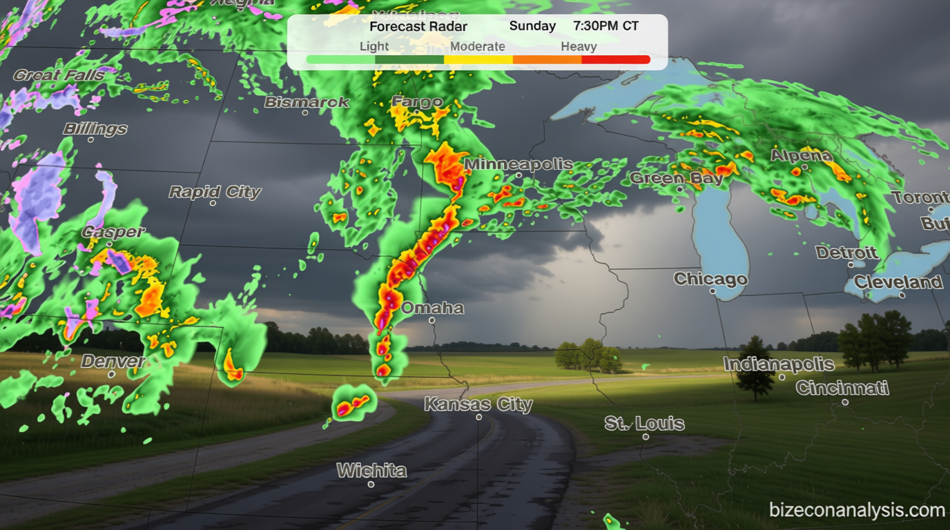
Sunday: Tornado Threat Peaks in Key Regions
Sunday will see the first major impact of the developing storm system, with thunderstorms rapidly forming during the mid to late afternoon over Nebraska and southeastern South Dakota. These storms are anticipated to deliver large hailstones, with potential for tornadoes emerging as the day progresses. The National Weather Service highlights that the peak threat for tornadoes will occur between 4 p.m. and 10 p.m. CT, targeting eastern Nebraska, southeast South Dakota, and western Iowa. Cities like Omaha, Lincoln, and Sioux City will be in the crosshairs of this hazardous weather. While the storm system is expected to remain active, its strength may vary depending on atmospheric conditions that develop in the early hours.
The timing of these storms is critical, as the region’s weather patterns have been unusually quiet this month. The initial suppression of severe activity has created a backlog of energy, which is now being released as the jet stream shifts. This volatility means that while Sunday’s storms are the first wave, they may not be the last. The forecast suggests that the Central US could experience a period of heightened risk, with the potential for multiple tornadoes to form in a concentrated area.
Monday: Widespread Outbreak of Severe Weather
Monday is poised to bring an even more extensive outbreak of severe thunderstorms, driven by the interaction between a powerful jet stream surge and abundant moisture in the Plains. This dynamic is expected to generate supercells capable of producing tornadoes with EF2 strength or greater, along with large hail. The primary threat zones will stretch from central and eastern Kansas into southeastern Nebraska and northwestern Missouri, where the most severe conditions are anticipated.
However, the forecast isn’t without uncertainty. Morning storms and their cloud cover could influence the afternoon’s energy levels, potentially reducing the intensity of the system as it moves through the day. This variability makes it challenging to pinpoint the exact areas with the highest tornado risk, as some regions might see a decline in activity while others experience a surge. Despite this, the overall pattern remains consistent: a significant increase in severe weather compared to the previous weeks.
By late evening, the focus will transition from tornadoes to damaging winds. While winds may diminish in strength, the risk of widespread gusts will persist, affecting both rural and urban areas. The National Weather Service notes that even after the peak tornado threat passes, the impact of these storms will be felt for several hours into the overnight period. This transition underscores the complexity of the weather system, which remains in flux as it moves across the region.
Tuesday: Storm Shift East, Tornado Risk Eases
On Tuesday, the storm system will move eastward, with thunderstorms likely to develop from northern Texas to Michigan. The potential for strong to severe storms will increase through the afternoon, but the tornado threat is expected to wane as a cold front becomes the dominant trigger for activity. This shift will lead to a focus on wind and hail, rather than tornadoes, as the primary concerns for the region.
Although the risk of tornadoes will decrease, the weather remains unpredictable. The cold front’s arrival could alter the storm’s trajectory, potentially leading to new areas of activity. This change highlights the importance of continuous monitoring, as even a slight adjustment in the system’s behavior could have significant implications. The transition from tornado risk to wind and hail threats marks the evolving nature of this weather event.
Fire Risk in the Southwest: A Concurrent Threat
As the storm system moves across the Central US, the Southwest is also preparing for a different kind of danger. The same atmospheric conditions that foster severe storms are creating an environment ripe for wildfires. A level 3 of 3, extremely critical fire threat is in place across the Southern High Plains, particularly from southwestern Kansas to the Texas Panhandle and northeastern New Mexico. This elevated risk is due to a combination of dry fuels, high wind speeds, and low humidity, which could allow any sparks to ignite rapid, life-threatening blazes.
“Sustained winds of 25 to 30 mph, gusts up to 50 mph, and relative humidity under 10% will combine with dry fuels causing any fires that ignite to spread at a life-threatening pace,” states the National Weather Service.
The fire threat is not limited to the Southern High Plains. A level 2 of 3, critical threat extends to much of New Mexico, indicating a broader area of concern. The system responsible for the severe weather in the Central US is simultaneously creating dry and windy conditions in the Southwest, which could exacerbate existing fire risks. This dual impact emphasizes the interconnected nature of weather patterns across the country.
While the focus of the storm system is primarily on the Plains and Midwest, its effects will ripple across the nation. The Southwest’s fire risk is a reminder that severe weather events can have far-reaching consequences, affecting regions not directly in the path of the tornado threat. As the week progresses, the balance between storm activity and fire potential will continue to shift, requiring attention from both meteorologists and emergency responders.
Overall, the coming days will test the resilience of communities across the Central US and Southwest. The transition from tornado threats to wind and hail, and then to fire risks, illustrates the dynamic and unpredictable nature of springtime weather. With the jet stream playing a pivotal role in shaping these conditions, the region’s residents should remain vigilant and prepared for the potential impacts of this weather event.
