
Hurricane Lowell passing just west of Hawaii, bringing heavy rain, strong winds, punishing waves
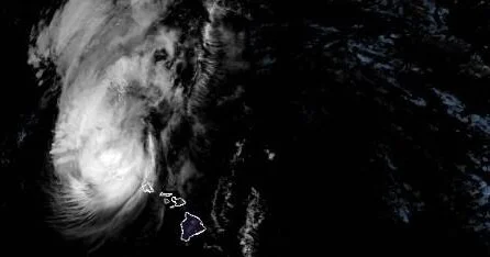
Hurricane Lowell Passing West of Hawaii
Bizeconanalysis.com – Hurricane Lowell passing just west of the Hawaiian islands delivered sustained winds near 110 mph, torrential downpours, and ocean swells dangerous enough to endanger anyone near the shoreline during the final hours of Monday local time. By the time the storm’s core and outer bands cleared overhead, tens of thousands of homes and businesses across the western islands had lost electrical service, according to the National Hurricane Center.
The system tracked north-northeast at roughly 18 mph, sitting just one mile short of the 111-mph threshold that would have elevated it to a major Category 3. At 11 p.m. local time, the storm’s center lay approximately 90 miles west of Lihue, the county seat governing both Kauai and the smaller island of Niihau. Hurricane-force winds extended outward up to 70 miles from the eye, so communities well beyond the direct track still faced sustained gales capable of toppling trees, severing power lines, and scattering debris across roadways.
Rainfall Totals and Flood Threat
The longest-lasting danger from the storm was water rather than wind. The Miami-based center projected that the system could unload as much as two feet of rain across portions of the island chain over the following hours. Breakdown by island:
“Lowell is expected to produce additional rainfall totals of 4 to 8 inches for Kauai, with maximum storm totals of 24 inches possible. For the Big Island, an additional 3 to 8 inches of rain is expected with isolated storm totals of 12 inches possible. We expect an additional 2 to 5 inches of rain for Oahu and Maui County, with isolated storm totals of 10 inches possible. This rainfall may produce significant flash flooding and mudslides, especially across Kauai County and portions of the Big Island.”
Those numbers carry outsized weight in terrain where steep volcanic ridges feed narrow valleys and aging drainage networks. Waimea Canyon on Kauai funnels runoff quickly into lower-elevation neighborhoods, while the Hilo side of the Big Island has a long history of debris flows following intense tropical rainfall. Residents in low-lying zones, near stream crossings, and beneath known landslide areas were urged to watch conditions closely and evacuate immediately if local authorities ordered it.
Marine Hazards, Tornado Watch, and Shelter Orders
Coastlines facing the storm’s track were flagged for what the center called “life-threatening surf and rip current conditions.” For beachgoers and small-boat operators, that meant waves of unusual size and irregularity, undertows pulling swimmers past their depth, and rip currents capable of dragging even strong swimmers offshore within minutes. Shoreline access was effectively discouraged through the night and into Tuesday morning.
A separate alert covered rotating winds: a tornado watch remained in effect until 4 a.m. local time for Niihau, Kauai, and surrounding waters, encompassing both tornadoes and waterspouts tied to the storm’s outer rain bands. Though tornadoes remain rare in Hawaii compared with the continental United States, they are not unheard of during tropical events, and waterspouts over shallow coastal waters can generate localized gusts that damage boats and coastal structures.
The Hawaii Emergency Management Agency labeled conditions late Monday night as “very hazardous” in both Kauai County and on Oahu, directing residents to shelter in place for the duration of the night — staying indoors, away from windows, with a charged phone, flashlight, water, and necessary medications within reach. The agency stressed that outages could persist for hours or longer and that backup lighting and communication plans should be in place before anyone attempted to travel.
The hurricane warning applied specifically to Kauai County, while a tropical storm warning covered Oahu. Both advisories extended across a substantial portion of the Papahānaumokuākea Marine National Monument, a protected area spanning nearly 583,000 square miles of Pacific Ocean and encompassing ten Hawaiian islands. Vessels operating within the monument’s boundaries were expected to encounter sustained tropical-storm or hurricane-force conditions, complicating any planned transit or research operations.
Frequently Asked Questions
Was Hurricane Lowell passing just west of Hawaii a Category 3 storm? No. It remained a Category 2 with sustained winds near 110 mph, just one mile short of the 111-mph Category 3 threshold.
How much rain did the storm threaten to drop? Up to two feet in isolated locations. Kauai faced 4–8 inches of additional rain with storm totals potentially reaching 24 inches; the Big Island 3–8 inches with isolated 12-inch totals; Oahu and Maui County 2–5 inches with isolated 10-inch totals.
Were there tornado or waterspout risks? Yes. A tornado watch covered Niihau, Kauai, and surrounding waters until 4 a.m. local time, accounting for both tornadoes and waterspouts from the storm’s outer bands.
What did emergency management direct residents to do? The Hawaii EMA ordered shelter-in-place for Kauai County and Oahu, advising people to stay indoors away from windows, keep phones charged, and avoid travel until outages were resolved.